![]()
Top-quality Owner Financed land for sale at the famous Bull Shoals Lake in the Ozarks of Northern Arkansas! Adjacent to the shoreline at Bull Shoals Lake you will find THOUSANDS of acres of Corp of Engineers Land which can be used for additional hunting and recreation, as well as for access to the water for fishing, swimming, boating and more! Each of these beautifully wooded tracts directly borders the Corp of Engineers Land (also called the “Take Line”) which gives you direct access to miles of shoreline as well as hundreds of acres (actually, thousands of acres) of Public Land which can be used for hunting, fishing, hiking and numerous other activities.
These stunning tracts are brought to you by our Sales Partner “Outcast Land Inc.” — Outcast Land Inc. is known for focusing on the highest quality hunting, fishing and recreation land in the United States.
Outcast Land is committed to bringing you the HIGHEST QUALITY recreation land in the nation. All Outcast Land tracts are located in areas with a PROVEN track record for deer and turkey hunting, and in this case that also includes world class fishing! The “Hunting and Recreational Developments” brought to you by Outcast Land have basic Covenants in place to ensure that the tract you purchase can be used for hunting, fishing and recreation for generations to come. By the way, all tracts sold by Outcast Land are buildable for a cabin or home once the property has been paid for in full, subject to the basic property covenants (although most Outcast Land customers are more interested in deer “signs” then street signs).
Although the properties sold by Outcast Land Inc. are buildable for a home or cabin and are “residential” as well as “recreational”, they can not be used as a residence until after the owner-financed loan has been paid in full. Although this does not affect the hunters, anglers or recreational users, it could affect folks who are looking for a place to immediately build and live. If you are looking for a place to immediately build and live than please contact us and we can let you know what is available that might suit your needs. This top-quality owner financed land is possibly the perfect acreage for fishing, hunting, camping, recreation and for creating lifelong memories with family and friends. Each of these tracts has numerous areas that are suitable for building a home or a cabin and once the owner financed loan has been paid in full you would be welcome to live on the property (subject to the basic property covenants as shown within this listing page).
Available Tracts
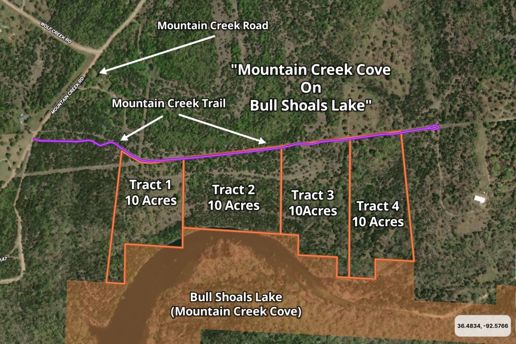
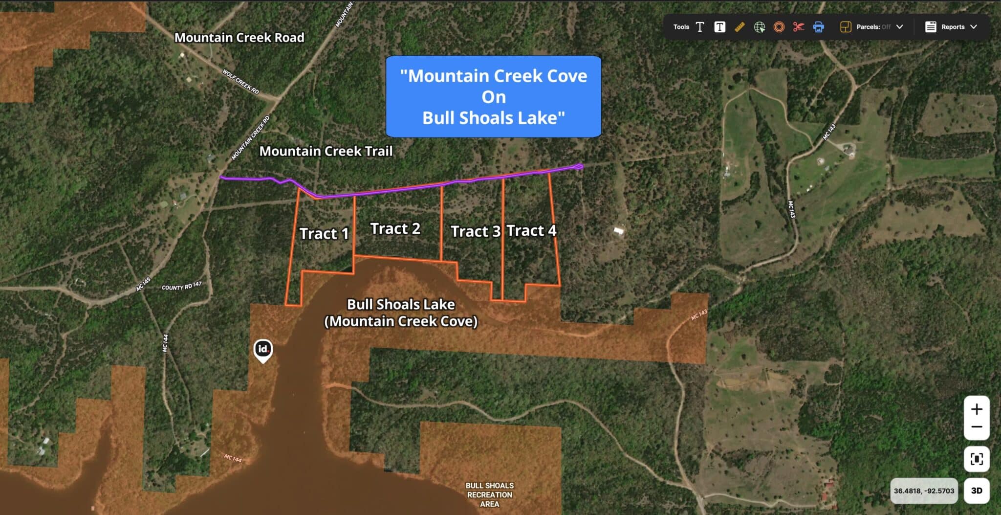
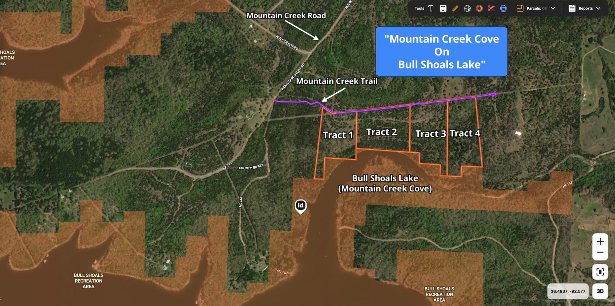
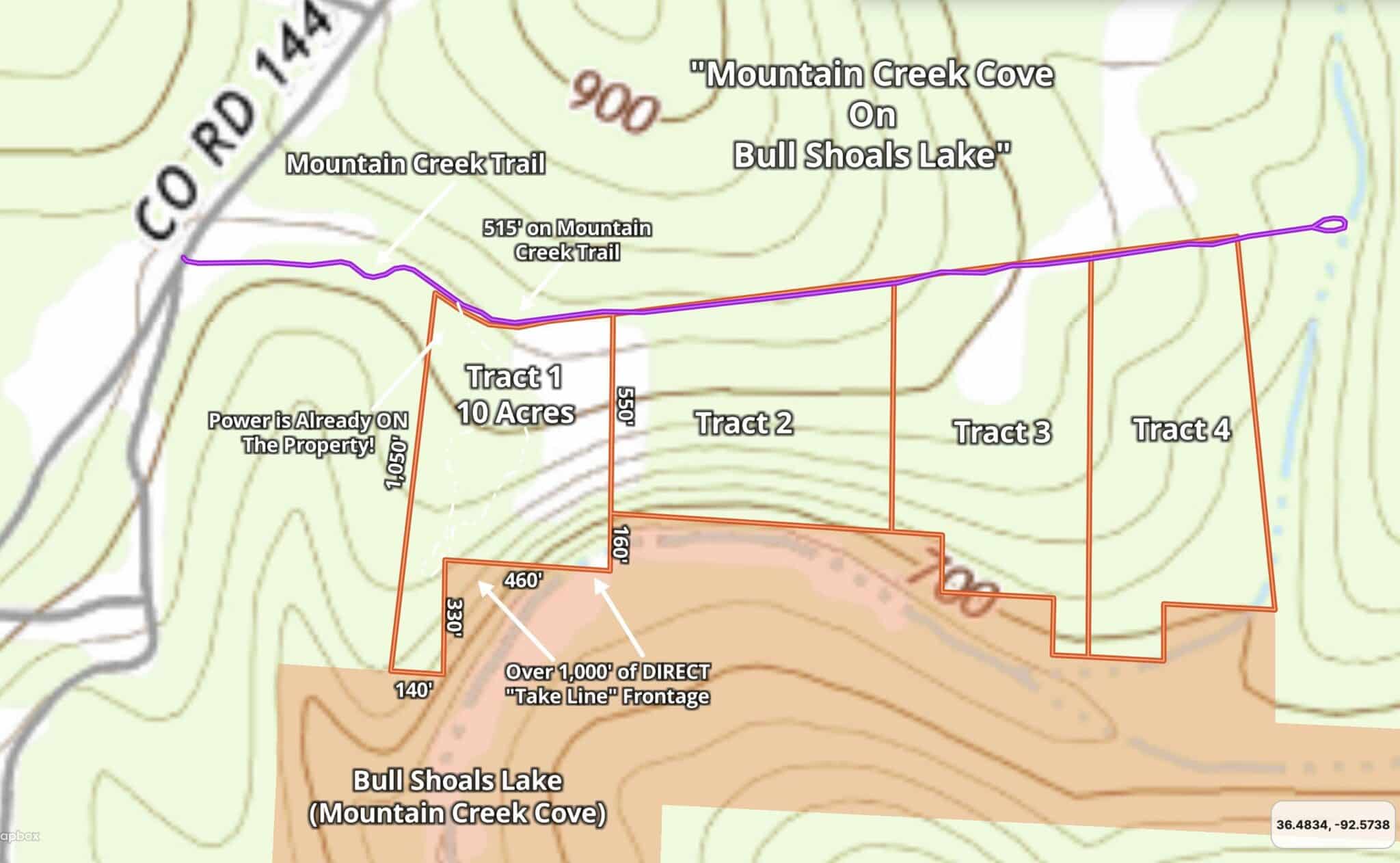
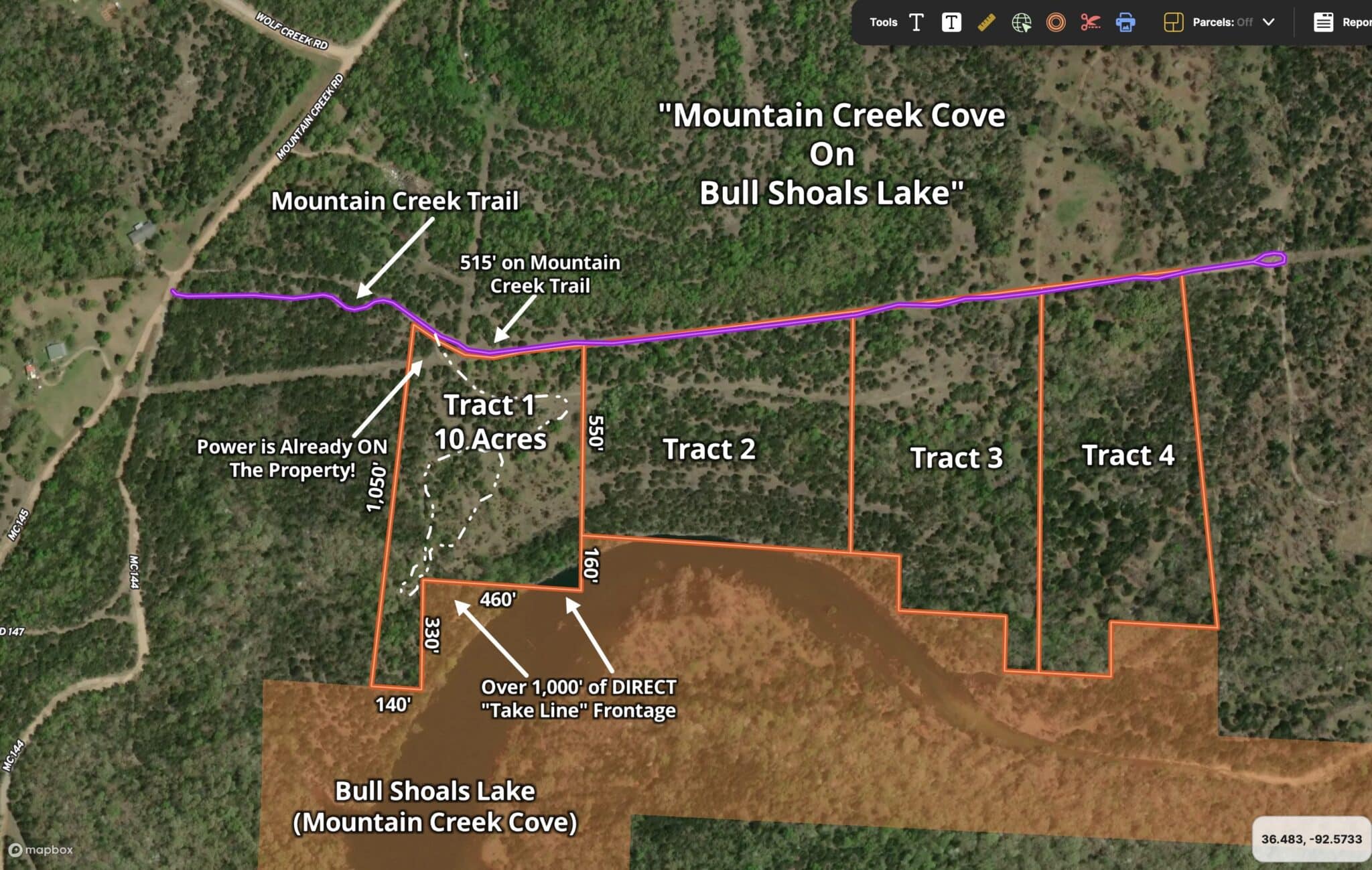
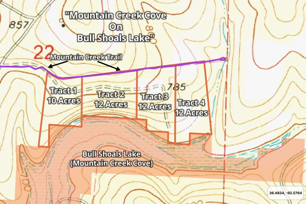
Below you will find a map showing the 4 tracts at “Mountain Creek Cove on Bull Shoals Lake” which is located in Marion County, Arkansas. Directly below the map you will see a list showing the available tracts along with their prices and some of their features. Click on the tract number of any available tract (within the list) to see the full information page for that tract.
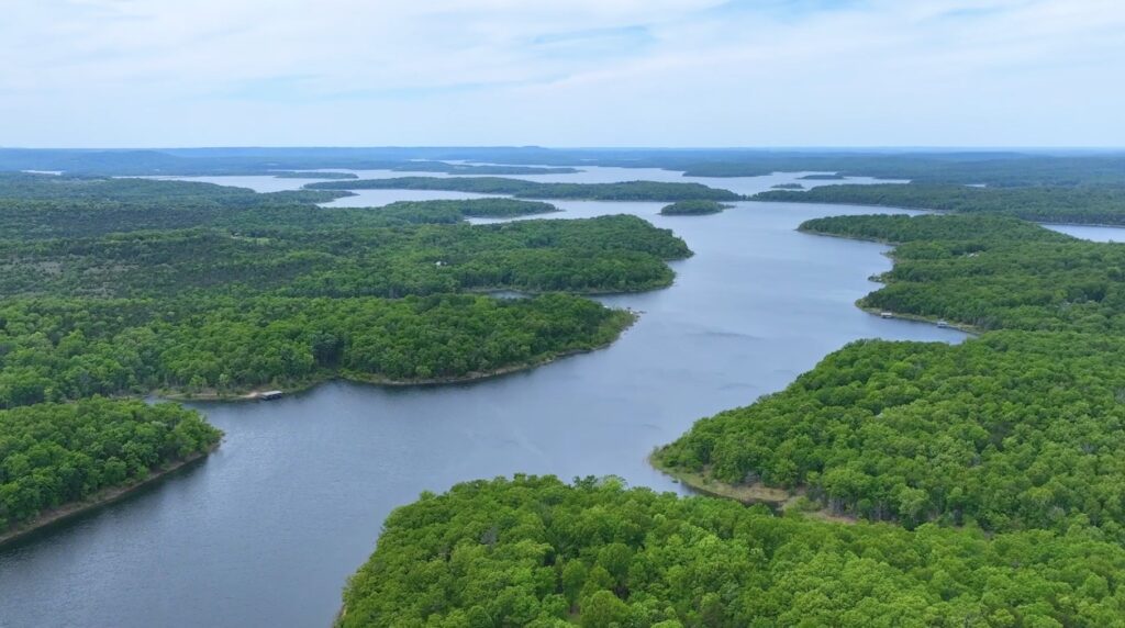
Aerial Map Shown Above
Within the individual listing page for each tract we have included multiple maps, pictures and videos that show these amazing properties in more detail. When you click on an available tract in the list above you can watch the videos and see the photos and maps for that specific tract.
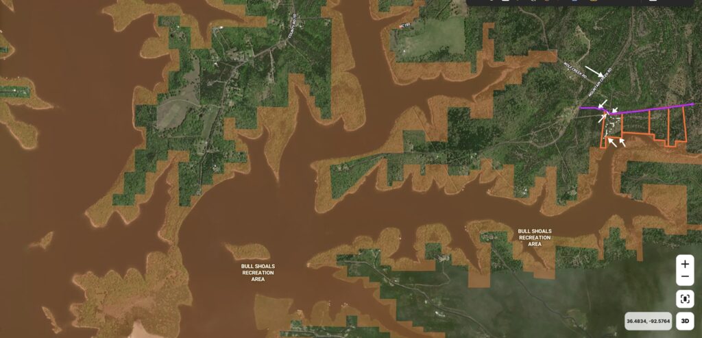
You may notice on the map above that all of these special tracts have direct frontage on the “Take Line” at Bull Shoals Lake along their south sides, which gives you direct access to the water and the thousands of acres of Corp Land that surround the lake.
As you explore this area of the lake you will find numerous places where you can launch a boat or a jet ski. Bull Shoals Lake is a fantastic lake that is suitable for boats of almost any size.
Bull Shoals Lake is world renowned for its bass fishing with numerous major tournaments being held on the lake. But, you can actually catch numerous species of fish in this HUGE lake including catfish, walleye, stripers and many other species. Because of the fairly mild winters in the Ozarks you can fish Bull Shoals Lake year around (giving you unlimited opportunities to land your trophy fish).
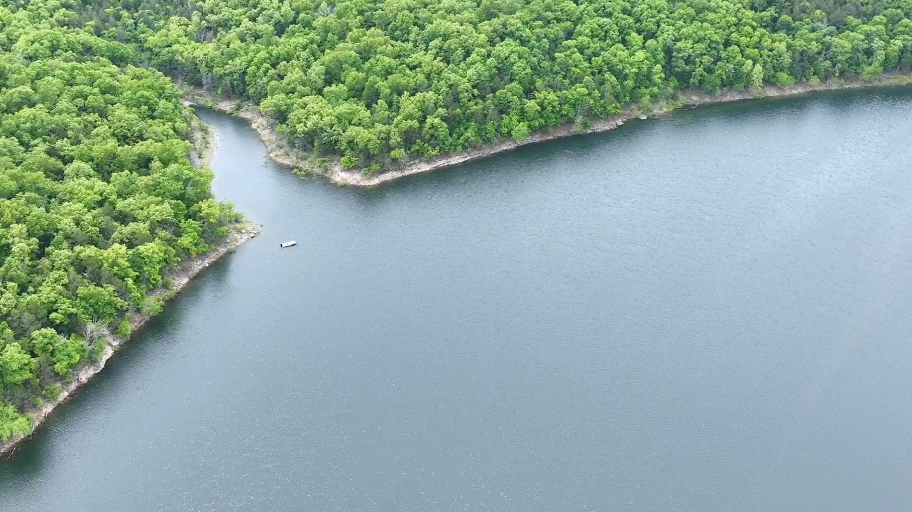
Map showing a small part of Bull Shoals Lake
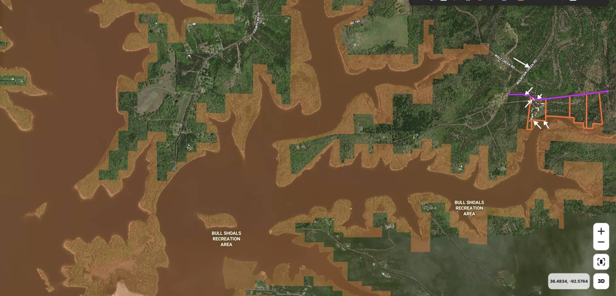
The aerial photo above shows how the property is situated, and also shows a small part of the east edge of Bull Shoals Lake. Bull Shoals Lake is a “Corp of Engineers” lake which means it was created and is maintained by the Army Corp of Engineers. On all “Corp of Engineers” lakes, the water itself as well as a buffer area around the water is actually owned/controlled by the Corp of Engineers. As a property owner with frontage on the Corp Of Engineers Line (also called the “Take Line”), you are able to directly access the Corp Land and to use this additional land for hunting and recreation as well as to cross over, in order to access the water.
As private individuals will not generally own the actual water front on Bull Shoals Lake, a property that has frontage on the “Take Line” can generally be considered lakefront (especially if it is close to the water).
Because the Corp Of Engineers Land is also open for hunting and recreation, you actually have direct access to several thousand acres of additional hunting land and several hundred miles of shoreline on the lake! You can own your own private acreage at Mountain Creek Cove and have direct access into a HUGE amount of additional land for hunting and exploring (as well as miles and miles of the shoreline of Bull Shoals Lake for fishing and swimming).
This is an amazing opportunity to own and enjoy a high quality piece of real estate while watching the value rise. Build your home or cabin and go fishing for your breakfast, lunch or dinner on the world famous Bull Shoals Lake. Or, just spend a few weeks every year camping, fishing, hunting and enjoying your property with family and friends (or all by yourself, which is one of our favorite ways to enjoy a property).
Bull Shoals Lake offers numerous water-sport activities including fishing, swimming, jet skis, water skiing, tubing and so much more. Bull Shoals Lake is sometimes referred to as “The Caribbean of the Midwest” because of its exceptionally clear and unpolluted water. This gives the lake incredible visibility and makes it one of the few lakes where you can successfully go scuba diving and snorkeling (you can rent the gear if you don’t have it). There are numerous marinas on this huge lake at which you can rent all different types of boats by the day or the week, including:
- Pontoons
- Bass Boats
- Jet Skis
- Deck Boats
- Ski/Wakeboard Boats
- Even Houseboats!

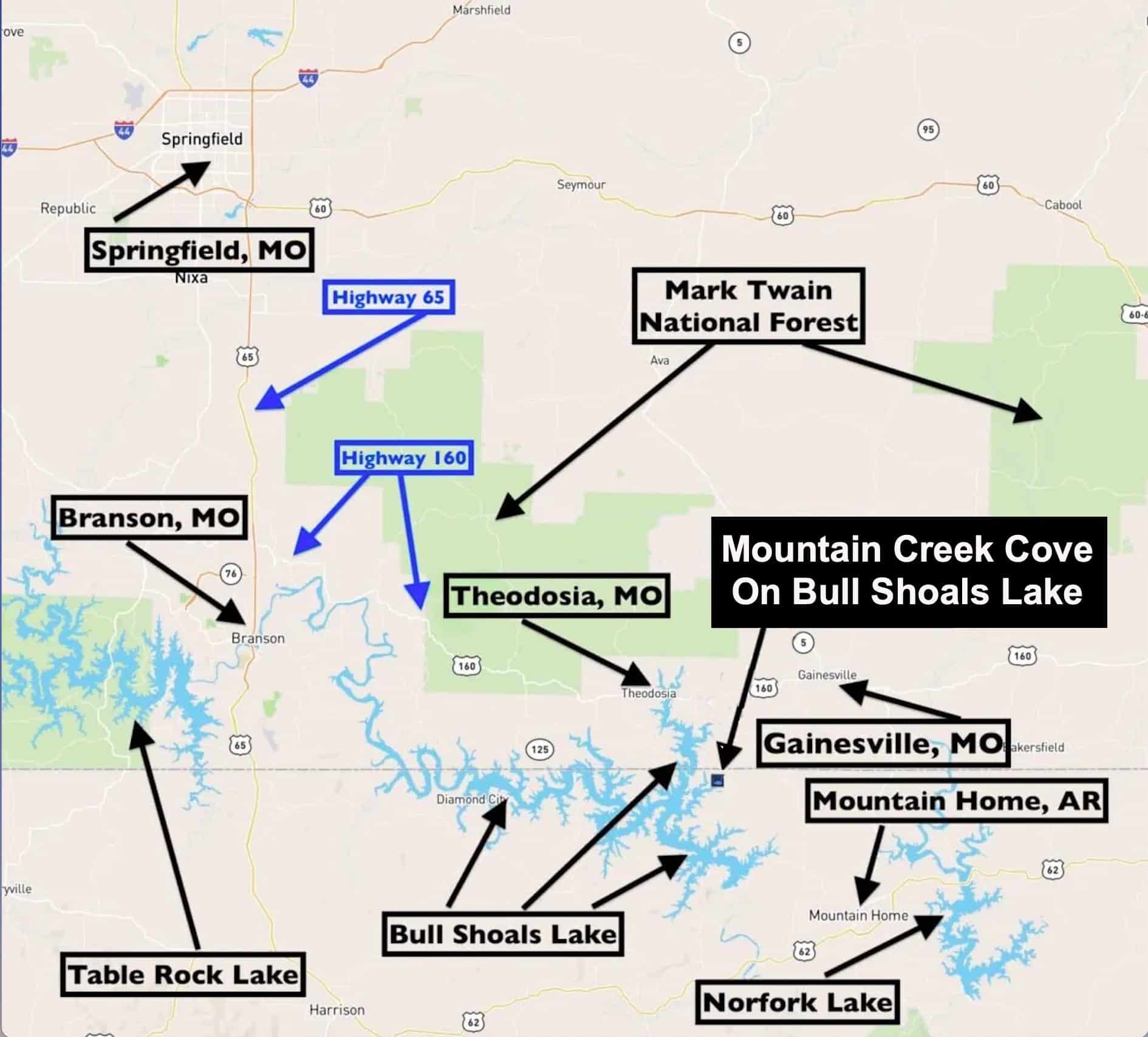
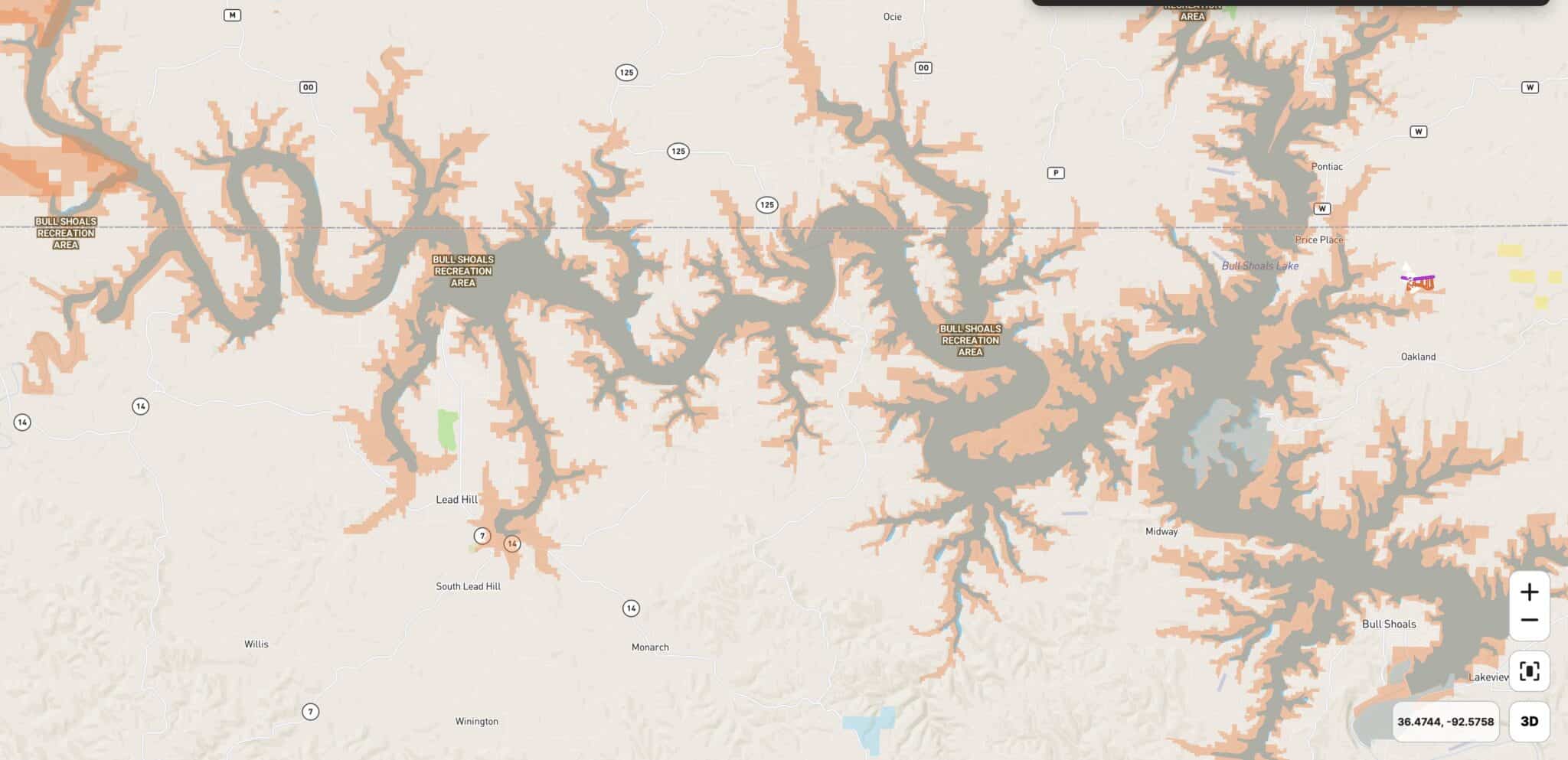
The map above shows Bull Shoals Lake as well as two other major Corp of Engineers Lakes in the Ozarks. Table Rock Lake is to the west (near Branson, Missouri) and Norfork Lake is to the east (it is actually just a few miles east of these tracts). The tracts at “Mountain Creek Cove on Bull Shoals Lake” are located on an excellent part of Bull Shoals Lake (far east side). They are about 10 miles southeast of Theodosia, Missouri which is a well-known town on Bull Shoals Lake. Theodosia is a small town but it has just about everything you need to enjoy life at the lake including stores, restaurants and several area marinas where you can rent a boat (or possibly a slip/dock if you want to store your boat in the water).
The town of Gainesville, Missouri is another small town in the area and it is about 15 miles to the northeast of Mountain Creek Cove. If you continue heading to the east after visiting the town of Gainesville you will soon find yourself in the very convenient town of West Plains, Missouri. West Plains is probably the largest regional city in south-central Missouri and is about 45 miles northeast of Mountain Creek Cove.
If you head west from the properties you will find that Branson, Missouri is about 40 miles to the west and Springfield, Missouri (which is by far the largest city in southern Missouri) is about 60 miles to the northwest.
These tracts are located in Marion County, Arkansas and are just a couple of miles south of the Missouri/Arkansas border. Going south from these tracts, you will quickly find yourself exploring the tiny town of Oakland, Arkansas (which is just 2-3 miles south of Mountain Creek Cove).
Mountain Home, Arkansas is about 20 miles southeast of the properties and is a beautiful regional city with numerous stores and restaurants. In regard to size and amenities Mountain Home, Arkansas is often considered a similar city to West Plains, Missouri (except that Mountain Home is in northern Arkansas and West Plains is in southern Missouri).
As you saw earlier in this listing page, the “Corp of Engineers Land” (the “Take Line”) is open for public hunting and recreation but if you desire even MORE hunting/recreation land than you will want to check out the “Mark Twain National Forest” which provides you with well over 100,000 acres of additional public land for hunting, trail riding, hiking and exploring. In the immediate area you will find two large sections of the Mark Twain National Forest, which are shown as the large green shaded areas on the map above.
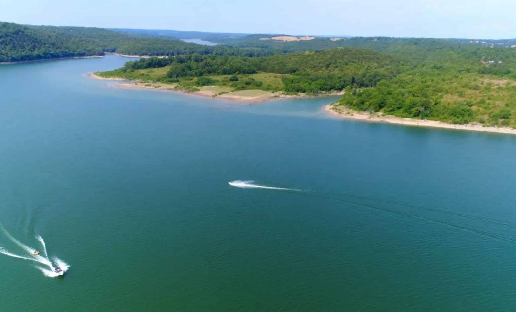
Bull Shoals Lake has several HUNDRED miles of shoreline for you to explore. You could spend years on the lake and still not see it all.
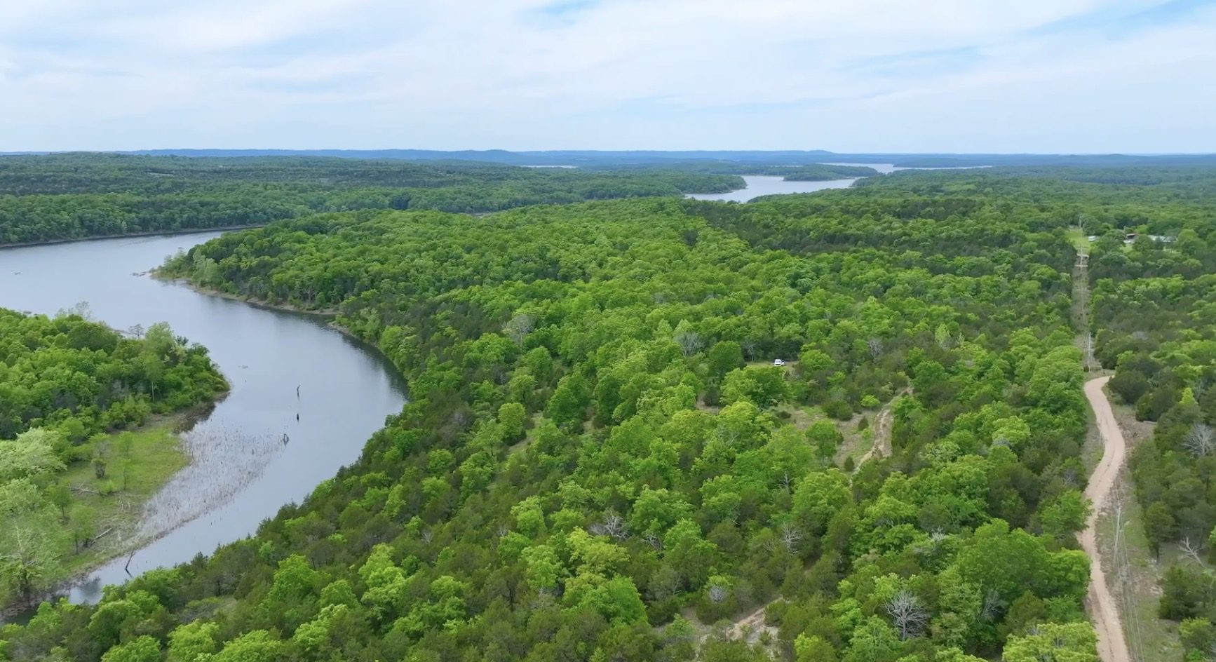
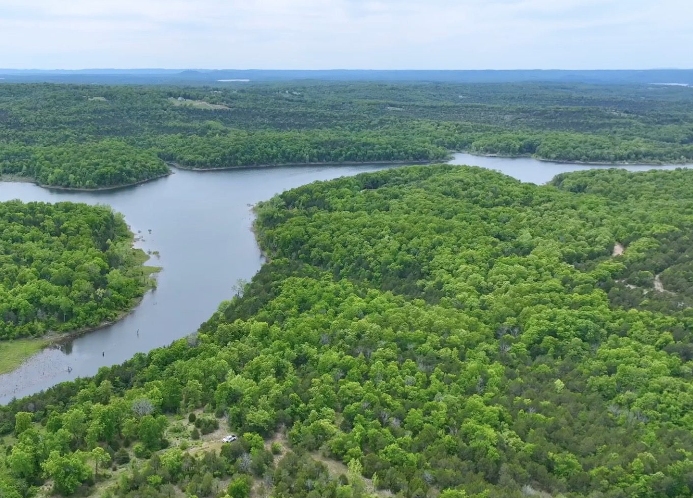
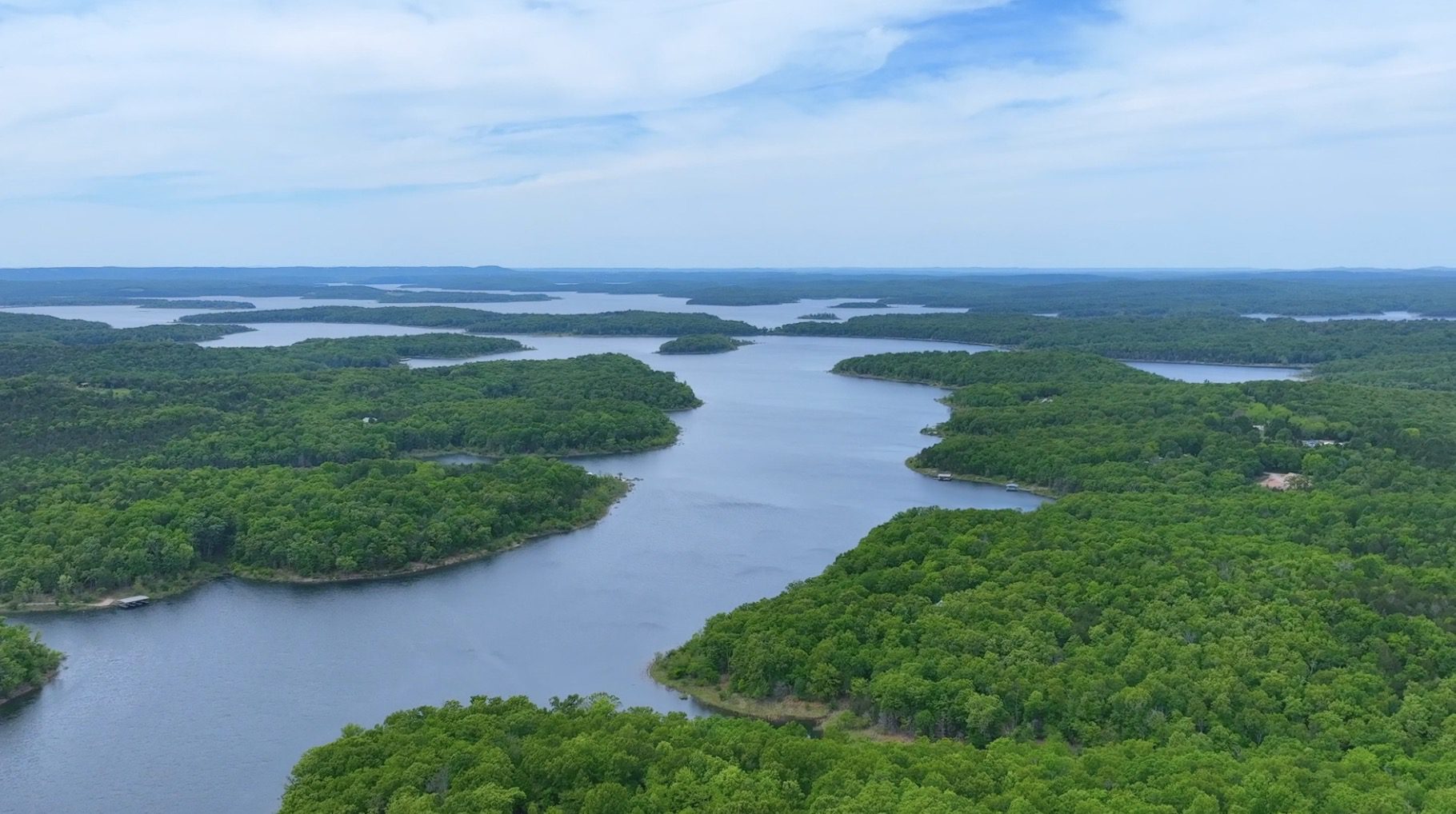
Aerial Photo Looking West from over the Properties
In the aerial photo above we are looking westerly from over the tracts at Mountain Creek Cove on Bull Shoals Lake. We can actually only see a small fraction of the lake in the photo (because it is enormous!).
All of the tracts have direct access from Mountain Creek Trail on their north side (some tracts already have a driveway installed and some do not). All of the tracts have power available with an electric line running adjacent to Mountain Creek Trail at the north side(s) of the properties. Having an electric line directly available on your property will be VERY convenient if you ever decide that you would like to have electric service. Even if you do not plan to build or hook into the power line, simply having it on the property adds a huge amount of value if you ever decide to sell your property as most people who want “lake land” also want to have power available.
These tracts are located in an area that is well-known for wildlife. We have seen numerous deer and turkey when we have visited the tracts. These private tracts are definitely suitable for hunting AND you can generally also hunt in the Corp of Engineer’s Land as well, which gives you thousands of acres of additional land to use and enjoy. You can fish from the shore of the lake or from your boat/canoe/etc. on Bull Shoals Lake, and this huge lake is known for having record-breaking fish! In fact, each year several fishing tournaments are held in numerous locations on Bull Shoals Lake. There are numerous species of fish in the waters of Bull Shoals Lake, and it is one of the few places in the country where you can fish for bass and trout in the same waters.
As we mentioned earlier, electric is already directly on the north side of each of the tracts. Being outside of city limits means you will not find public water/sewer available (but also means these tracts are not subject to the strict regulations you would find within city limits). If you require a permanent water source you could drill a well or for occasional use a cistern (water collection/storage) can be a good choice. For septic, you could install a standard septic (which can potentially be done yourself, if you desire) or possibly use an alternative style system (such as composting toilet or one of dozens of other systems that are now on the market). For occasional use, an “rv style” toilet works well (as do numerous of other options). We had cell service in the areas we checked within the development (we use Verizon). The wireless internet in the truck seemed to function just fine within the development.
HUNTERS, FISHERMEN (and FISHER-WOMEN), CAMPERS AND RECREATIONAL LAND USERS have specific desires and requests when they are searching for a property. In general, these folks plan to camp and use their recreational property more often than most people. They also generally do not plan to build a home and live on the property in the near future.
With these specific needs in mind, Outcast Land is proud to bring you this “Recreational Development”. All of the tracts within this rural development are usable for hunting, camping, recreation and also for building a home or cabin, but there are a couple of important distinctions that make these tracts special:
- All Outcast Land tracts are buildable but please keep in mind that they can not be used for a permanent residence until after the loan (to us) has been paid for in full. You can definitely build a cabin (or use a portable building) for camping and hunting, but in order to live on the property the loan must be paid in full and your residence must be at least 600 square feet in size and be built on a permanent continuous concrete foundation.
- Camping is allowed for up to 90 days a year, instead of the standard 45 days. This gives you twice as much camping/hunting time on your acreage.
- You can ALWAYS camp, for hunting purposes, during the scheduled deer hunting (rifle season) and turkey hunting seasons (even if that would put you over the 90 day period). Outcast Land does NOT wish to limit your hunting opportunities on your property.
Other property covenants (setback distances, etc) will be very similar to the standard Property Covenants that you see within the InstantAcres.com “property covenants” section. To see the Outcast Land Property Covenants for Mountain Creek Cove at Bull Shoals Lake please click on the link below:
Click Here To see the Property Covenants for Mountain Creek Cove on Bull Shoals Lake
Hunters, Anglers and Recreational land buyers generally have no interest in living on their property in the near future (although often they do plan for a retirement home/cabin on the property). BUT, many hunters, campers and recreational land buyers do tell us that it can be a hardship to have nearby neighbors living in portable buildings, camper trailers or homemade “tiny homes” while they attempt to enjoy their acreage for hunting & recreation with their families and friends.
We love “homesteaders” (in fact, we have an entire category on our website specifically for homesteaders) and you may also love “homesteaders” but these tracts from Outcast Land are not designed for the “homesteader”. These tracts are designed for the serious angler/hunter/camper/recreational user who does not desire to be surrounded by homesteaders while hunting, camping and using their property.
Please note that timber with a stump diameter larger than 8 inches may not be cut, sold or removed until the owner financed loan on the property has been paid for in full (we can often give written exceptions for creating or expanding a building site or a driveway/trail).
Because there are a number of marinas and campgrounds around Bull Shoals Lake, it may be convenient for you to look into renting a cabin or an RV site nearby while you work on your property or while you clear a driveway and/or a building site on your property. Trees with a stump diameter of over 8 inches (measured at ground level) can not be cut or disturbed until the property has been paid for in full BUT we do recognize that in order to clear a driveway and a site it is almost always necessary to remove some mature timber. Because of this, we have a very simple program in place with which you can generally get written permission to remove the necessary trees (often we are able to give written permission within 1-2 days, or less). Contact us for details about obtaining written permission for tree removal if you wish to create or expand a building/camping site on your tract at Mountain Creek Cove on Bull Shoals Lake.
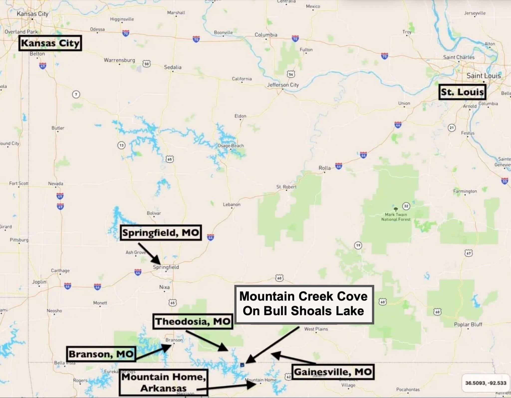
These special tracts are ideally located, a little over an hour southeast of Springfield, Missouri. You can fly into Springfield and be on your private paradise at the lake before lunchtime!
The lakes, rivers, National Forest and friendly people make this area a fantastic place to spend the weekend or a lifetime.
The Ozarks of Northern Arkansas and Southern Missouri have been a well-kept secret for many years, but the rest of the world is starting to discover this area… It’s just a matter of time before land prices here catch up to the rest of the Country!
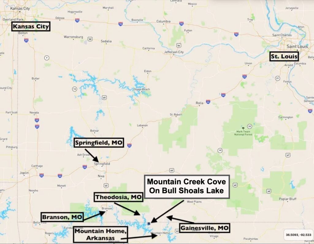
State Map
The map above shows the location of Mountain Creek Cove, relative to Springfield, Missouri as well as Theodosia, Missouri, Mountain Home, Arkansas and Gainesville, Missouri.
Let’s take a closer look at the tracts at “Mountain Creek Cove on Bull Shoals Lake”!
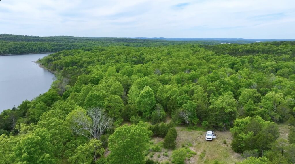
Truck parked on the property
In the aerial photo above we are looking down at an open area on one of the tracts. The white truck is parked within the open area and all around the truck you can see large mature timber. Mountain Creek Cove is off to the left in this photo and it is accessible from the property. If you look way off into the distance on the right side of this photo you can see more of the open waters of Bull Shoals Lake. In the tall, mature timber behind the white truck we found several nice walking/four wheeler trails which provide excellent access to numerous parts of this particular tract.
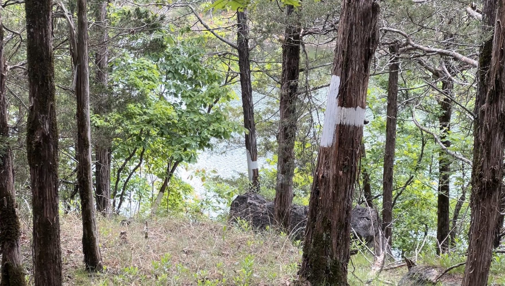
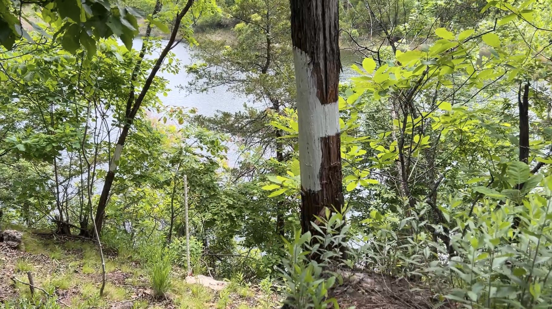
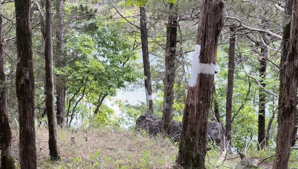
In the photo below you can see several trees that have been painted with a white “+” sign. This is one of the main ways that the Corp of Engineers marks the “Take Line”. They also commonly use white posts.
The photo above was taken while standing on one of the tracts within Mountain Creek Cove. We are facing south on the tract and just a few feet into the distance you can see Bull Shoals Lake. On the left side of the photo is the private tract and on the right side of the photo is the Corp Of Engineers land.
The Corp of Engineers Land can generally be used as public land (very similar to the National Forest) which you can use for hunting and recreation, and to cross over to get to the shoreline of the lake. Because the Corp of Engineers Land (just called “Corp Land” by almost everybody) is open for public hunting and hiking, you have access to thousands of acres of additional land that you can use and enjoy. Having such great access to the “Corp Land” gives you use of thousands of acres of additional land for hunting and recreation, AND also gives you access to hundreds of miles of shoreline on the lake that you can explore to find the best spots for fishing and swimming!
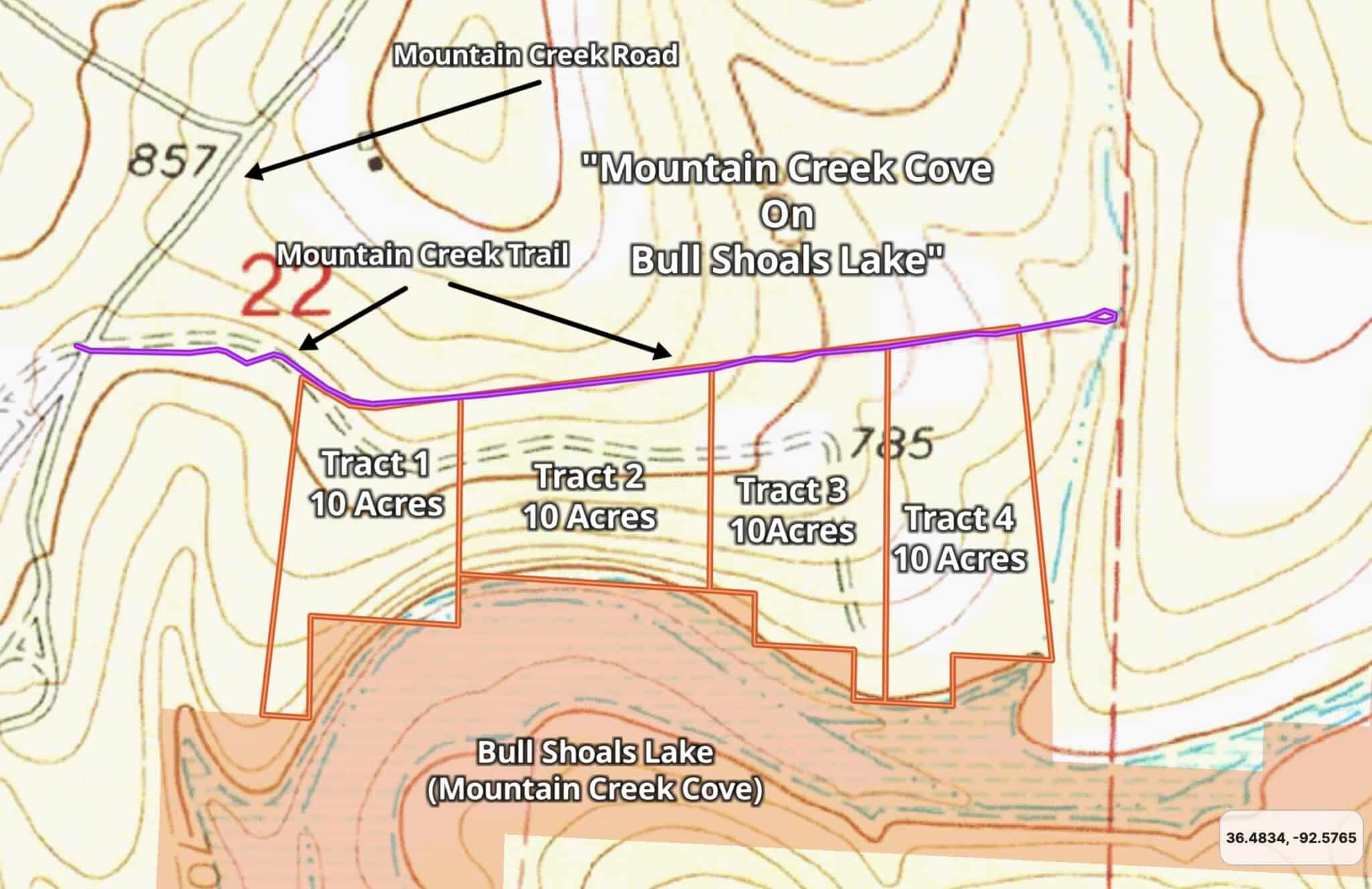
The topo map below shows the “lay of the land” around Mountain Creek Cove. This area is a mixture of highs, lows and everything in between. Although this area is the true “Ozarks” which is known for “hills and hollers”, all of the tracts appear to have more than enough level area for a large yard or to build just about any type of structure that you would like. some type of large level area which could be suitable for a large camping or building site. In general, as you drive onto a tract from Mountain Creek Trail the land appears to stay fairly level for a few hundred feet and then begins sloping down more quickly as you get closer to the lake (at the south side of the tracts).
Topo map above
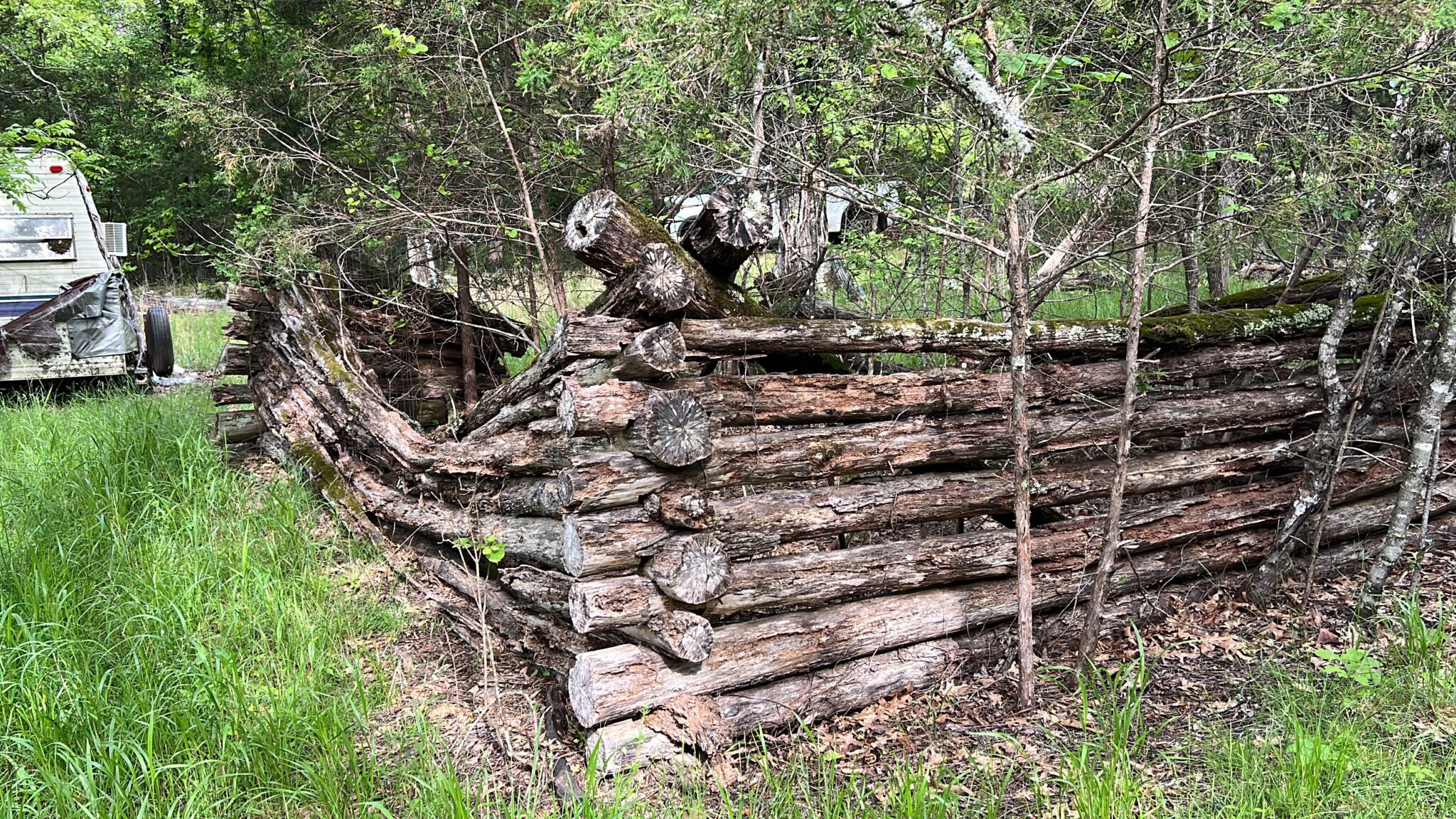
We found some type of old “trail system” on basically all of the tracts. On some tracts, we found what appeared to be old building sites or campsites. This actually makes sense since we were told that the land was once (many years ago) part of what was known as the “Mountain Creek Hunt Club”.
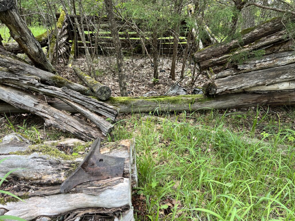
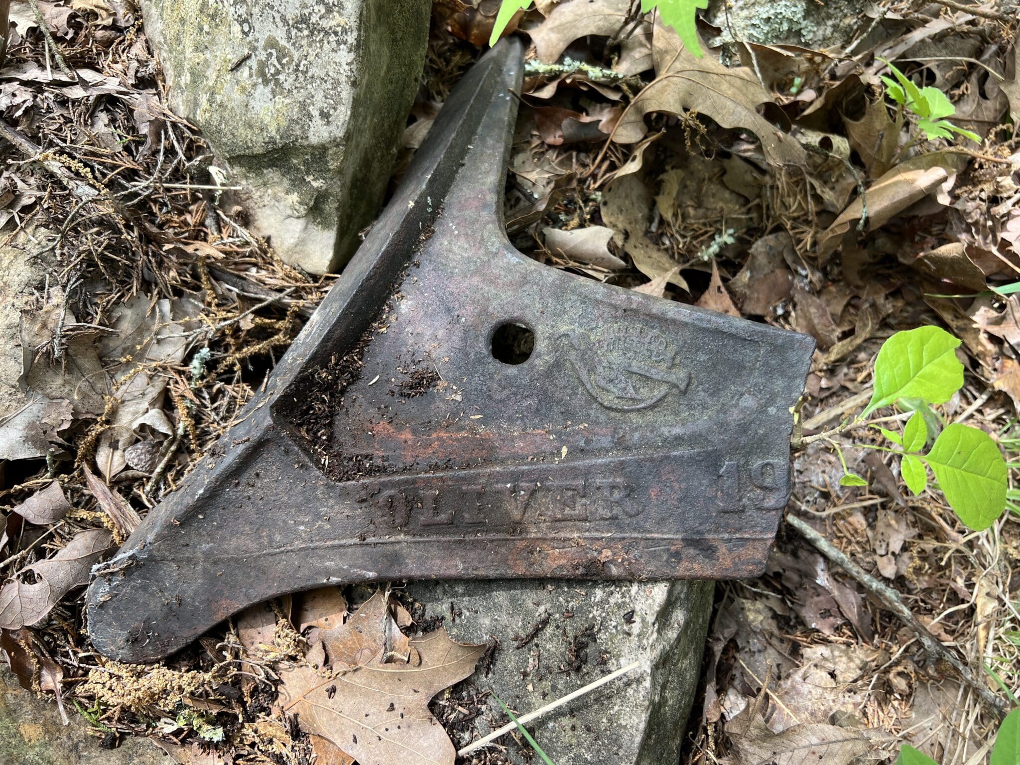
In the photo above, we are looking at an old log cabin that we discovered on one of the tracts. The piece of metal in front of the cabin appears to be part of a very old piece of farm equipment.
To get a much more detailed look at any of the specific tracts, please click on the tract number in the “table” toward the beginning (or toward the end) of this listing page. That will take you to the full listing page for any specific tract.
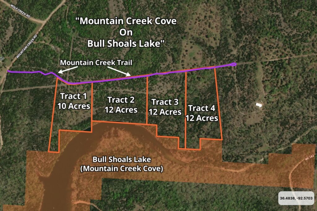
On the aerial map below (which is similar to the Aerial Map shown earlier in this listing page) you can see the four tracts within the Development. Tract 1 is 10 acres in size and Tracts 2-4 are each 12 acres in size. The purple line which runs with the north side of each of the tracts is Mountain Creek Trail. This road ends a little past Tract 4 which makes the area very private (basically no “through traffic”).

The Tracts at Mountain Creek Cove on Bull Shoals Lake
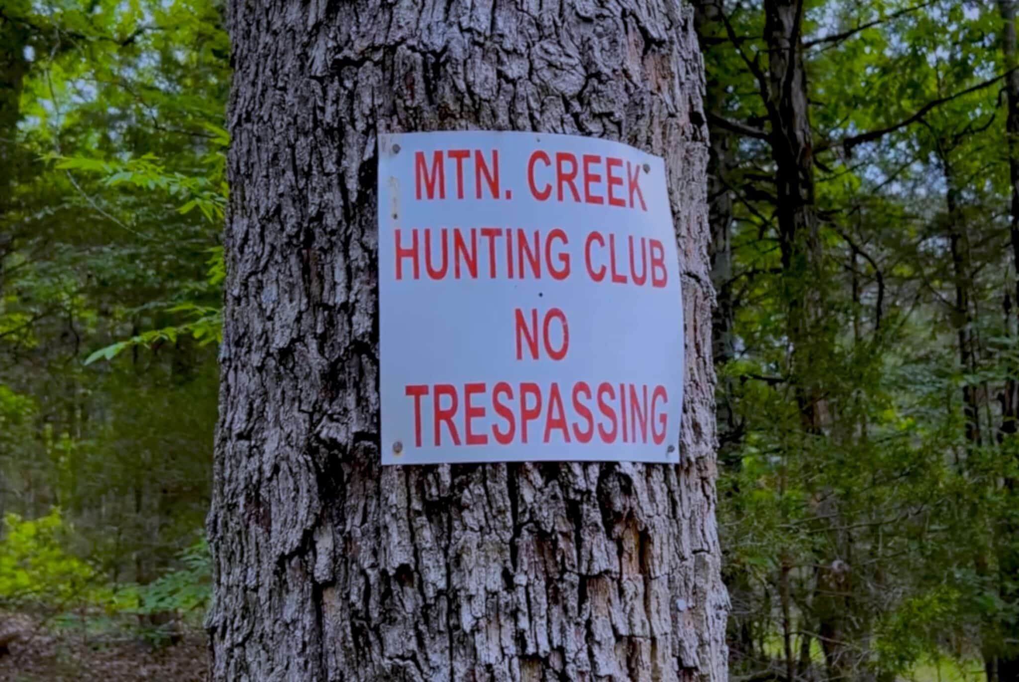
We were told that the acreage that comprises “Mountain Creek Cove on Bull Shoals Lake” was once part of a larger area which was known as the “Mountain Creek Hunt Club”. We have no idea when the “Hunt Club” was formed or when it ended but in several areas we found old signs and old campsites that do make it appear as though this was once part of a recreational hunting/camping area.
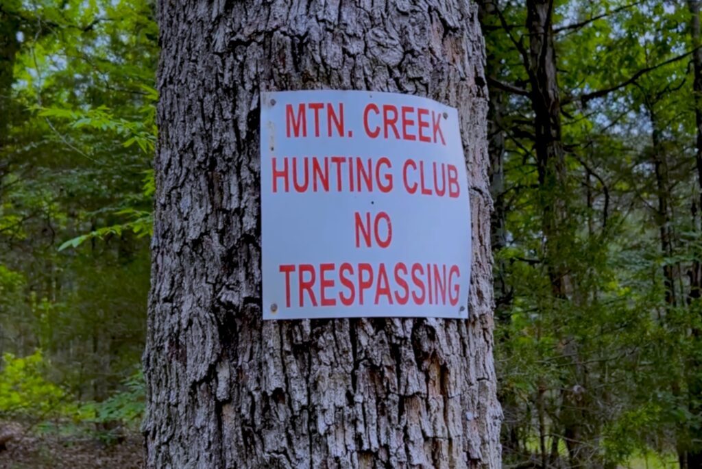
Hunt Club Sign
In the photo above you can see an old “Hunting Club” sign that we found on a tree on one of the tracts. This land was once part of some type of hunting club (years ago). This does explain the numerous trails and campsites that we continue to find on these special tracts of land.
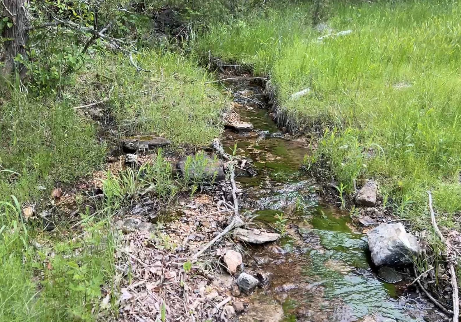
Also, in the short amount of time that we spent on the property we found what looked to be very old tools or farming implements and more than one “live spring” that appeared to come right out of the ground before flowing down toward the lake.
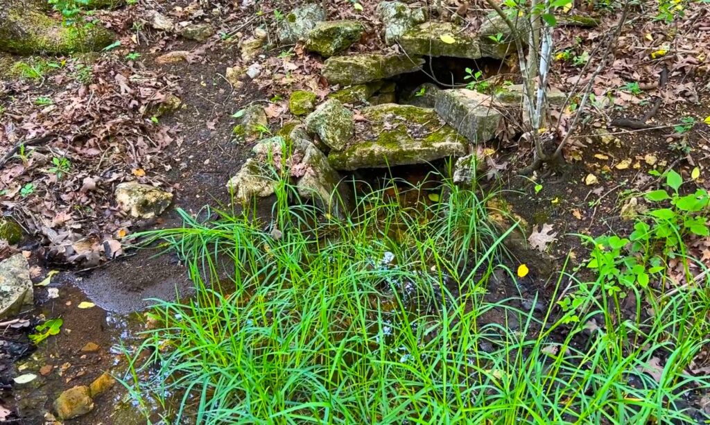
In the photo above we are looking at a live spring that comes out of the ground on one of the tracts. Although it is hard to see in the photo, the large rocks in the photo have been arranged to protect the area where the spring comes out of the ground. The rocks looked like they had been put there many decades ago. Very cool!
VIDEOS!
The first video is a “Drone Video” in which we do a “flyover” of the area and take a quick look at some of the tracts as well as a very small part of Bull Shoals Lake:

Next, we have included an “Intro Video” of “Mountain Creek Cove on Bull Shoals Lake” as well as the general area. This video is fairly long but it does include quite a bit of good information. In the video, we use the Mapright Interactive Map (which is now called “Land Id”) to explore the area:

The next video actually shows the drive into the properties. We begin the video on Highway 5 (south of Gainesville, MO) and we keep the camera running until we get to the tracts. Don’t worry though, we have “sped up” most of the video so that it becomes slightly less boring…:

All of the tracts at Mountain Creek Cove on Bull Shoals Lake are wooded and you can expect to find red oak, white oak, cedar, hickory and even walnut and pecan trees (as well as many other species). All of the tracts have access off of “Mountain Creek Trail” and although we only saw a couple of driveways leading into the tracts, it looked as though each tract had a couple of spots where it would be very easy to remove some brush to create a driveway into the property. If our guys are out in the area in the near future we would be happy to open up a driveway into any of the tracts which may not have one.
Because there are a number of marinas and campgrounds around Bull Shoals Lake, it may be convenient for you to plan to rent a cabin or an RV site nearby while you clear a driveway and possibly a building/camping site on your property. Generally, trees with a stump diameter of over 8 inches can not be cut or disturbed until the property has been paid for in full BUT we do recognize that in order to clear a driveway and a site it is very possible that you may need to remove some mature timber. Because of this, we have a very simple program in place with which you can generally get written permission to remove the necessary trees for a driveway and a building/camping site (often we are able to give written permission within 1-2 days, depending on the request and the circumstances). Contact us for details about obtaining written permission for tree removal for creating a driveway and building/camping site on your property.
This is investment-quality acreage in a fantastic location. These special tracts are some of the ONLY properties we have ever found at Bull Shoals Lake that offer road access AND have a power line already on-site. What makes these tracts EXTRA SPECIAL is the fact that each tract has DIRECT frontage on the “Take Line” which means you can go directly from your property over the Corp of Engineers Land and to the shoreline of Bull Shoals Lake for fishing, swimming, hunting and more.

Bull Shoals Map
The map above shows the famous Bull Shoals Lake which extends from east of Branson, Missouri all the way down to “Bull Shoals, Arkansas”. Bull Shoals Lake was created in the 1950’s by building a massive dam on the White River (for power generation and for flood control). In total, the lake has close to 1,000 miles of shoreline and about 50,000 surface acres of water.
Bull Shoals Lake is suitable for boats of just about any size but you will most often see bass boats, pontoon boats (often pulling a tube loaded with lake-loving kids) and jet skis traveling across its clear waters. Because of the massive size of Bull Shoals Lake, it is almost always easy to find a section with very few other boats, which makes it sooooo easy to pull a tube.
As anyone who has ever pulled a tube loaded with children can confirm, it is quite possibly the closest you will ever get to being able to buy your children’s love! Have a moody teenager? Get them onto a tube and watch their entire outlook on life change! Have a 6th grader who is perpetually bored? Pull them on a tube and suddenly they are telling all of their friends about their amazing parents who took them to the lake! We’re joking of course, but not very much…
By the way, the magic of pulling a tube also works its wonders on spouses, in-laws and generally just about anyone who hops onto the tube. Along with renting the boat to pull a tube, you can also rent all of the gear that you need (tube, tow rope, lifejackets) at several of the marinas on Bull Shoals Lake. You can pull a normal tube with any number of boats but our favorite is to use a pontoon boat because then everyone can ride along and watch the fun!
Also, if you have never ridden a jet ski then be sure to add that to your “To Do” list when you visit Mountain Creek Cove. They can be rented at some of the marinas and they are a fantastic (and very fun) way to explore the lake.
Below, we have an interactive map showing the tracts within “Mountain Creek Cove on Bull Shoals Lake” as well as the surrounding area. We have been using this mapping program for several years and it has always been called “MapRight” – but recently it has changed its name to “Land Id”. It functions almost exactly the same as it did before the name change, but they did change the look of the program and of many of the labels and buttons. It is still an awesome tool for exploring the properties and the area:
The Interactive Map above gives you a good look at the tracts at “Mountain Creek Cove on Bull Shoals Lake” as well as the general area. You can zoom in and out and move the map around to see the different tracts in detail. You can also change the “base layer” to see a topo map as well as other base maps. The property lines within the map are approximate but should give you a fairly good idea about how these private tracts are situated. The tracts have not been surveyed but there has been survey work done in the area which generally means that a survey could be done at a reasonable cost, if you desire to do so.
These tracts offer maximum privacy as they are located on a dead end road with basically no “through traffic”. Because many of the tracts extend back from the road for several hundred feet you could potentially have your building and/or camping site tucked away so that it was completely private.
It has always been difficult to find available land near Bull Shoals Lake and it has always been nearly impossible for us to find land with frontage on the “Take Line”. When you add to that the fact that these tracts are heavily wooded AND have an electric line on-site, you have a property with amazing investment potential that you can also use to create lifelong memories with family and friends.
It is continually getting harder and harder to find good-quality acreage for fishing, hunting and recreation (and building a home or cabin). With their privacy and excellent location, these tracts represent what we feel is one of the best investment opportunities that we have ever offered. Fish, camp, hunt and enjoy your property right away – and watch as the land values in this area continue to climb as more and more people discover Bull Shoals Lake and the beautiful Ozarks.
The fishing, camping, hunting and recreational opportunities in this area are awesome. These tracts are well-located for fishing, hunting, camping, building and recreation and Bull Shoals Lake is well-known as one of the best fishing and water-sports lakes in the United States.
Directions T0 – “Mountain Creek Cove on Bull Shoals Lake”
Coming from the North or West:
To get to “Mountain Creek Cove on Bull Shoals Lake” from the North or West (coming from the direction of Springfield, Missouri) just go south Highway 65 out of Springfield for a little over 25 miles and then go east on Highway 160 (toward Forsyth). Head east on Highway 160 for about 40 miles and you will come to Theodosia, Missouri (you are getting closer!). After you cross the bridge over Bull Shoals Lake in Theodosia you will continue east on Highway 160 for a little over 10 more miles and then go right (south) onto Highway 5. Go about 4 miles on Highway 5 and then go west (right) onto Highway W. Go about 2 1/2 miles on Highway W and then turn south (left) onto County Road 619. This is a gravel road and the street sign may actually say County Road 622. Head southerly on this gravel road for about 3 1/2 miles and you will come to a “T” in the road. Go right at the “T” and go about another 1 1/2 miles and you should see the start of Mountain Creek Trail on the left side (east side) of the road.
Now head east on Mountain Creek Trail for a little less than 1/4 of a mile and you will see Tract 1 on the right side (south side) of the road. Continue heading east along Mountain Creek Trail if you are viewing Tracts 2, 3 or 4.
Coming from the East:
To get to “Mountain Creek Cove on Bull Shoals Lake” from the East (coming from the West Plains, MO area) just go west on Highway 160 out of West Plains for about 35 miles to the town of Gainesville, Missouri. From Gainesville, continue to proceed west on Highway 160 for about 2 miles and then go south onto Highway 5. Once you are on Highway 5, proceed the same as the directions above.
Coming from the South:
To get to “Mountain Creek Cove on Bull Shoals Lake” from the South (coming from the Mountain Home, Arkansas area) just go north out of Mountain Home on Highway 5 and proceed for a little less than 20 miles then head west onto Highway W. Now proceed the same as the first set of directions.
If you are coming in from the south the map shows that there are probably quicker ways to get to the property, but we didn’t want to send you on a route that we had not personally experienced.
If you would prefer to use a “street address” that you can input into Google Maps or Apple Maps you can use the address below (this should take you fairly close to the start of Mountain Creek Trail, which you would then take to the property):
000 Mountain Creek Trail
Oakland, AR 72661
Also, here are the GPS Coordinates at about the start of Mountain Creek Trail:
36.4836, -92.5768
What can you do on your new property at “Elm Hollow on Bull Shoals Lake”?
These tracts are NOT subject to the zoning regulations that you will find in most areas of the country. These tracts are within a Rural Development and do have basic property covenants BUT almost all of the Outcast Land buyers find that these covenants simply do NOT limit what they plan to do with their property. In fact, most Outcast Land buyers that we speak to would simply NOT buy a property without basic covenants in place to protect their investment.
At your property within “Elm Hollow on Bull Shoals Lake” you can:
- Fish from the miles of shoreline at the lake within the “Corp Land”
- Hunt on your property AND within the thousands of acres of “Corp Land”
- Camp
- Build a cabin or a home (subject to property covenants)
- Have a portable building or shipping container (for camping, hunting, recreation and storage)
- Use your camper or RV for camping, hunting and recreation
On your property at “Elm Hollow on Bull Shoals Lake” you can not:
- No commercial businesses
- Can not live on the property until the owner financed loan has been paid in full
- No cutting of the timber until the property has been paid for in full (we can often make written exceptions for clearing a building site or driveway)
- No junkyards of any kind
All of the tracts at Elm Hollow on Bull Shoals Lake have setback distances from the County Road for privacy and to maintain the natural “feel” of the area. These setback areas are also designated as potential future utility easements and as privacy buffers. All buildings, home sites, parking areas, storage areas, etc. must be at least 100 feet from the center line of the County Road (this area acts as a privacy setback as well as a future utility easement).
Fences/gates may not be placed within 50 feet of the center qeline of the County Road, as this area is a designated road easement area.
These tracts represent an excellent opportunity for building your own hunting cabin, as there are no building permits required in this area. You and your friends/family can build your own cabin without permits or inspections!
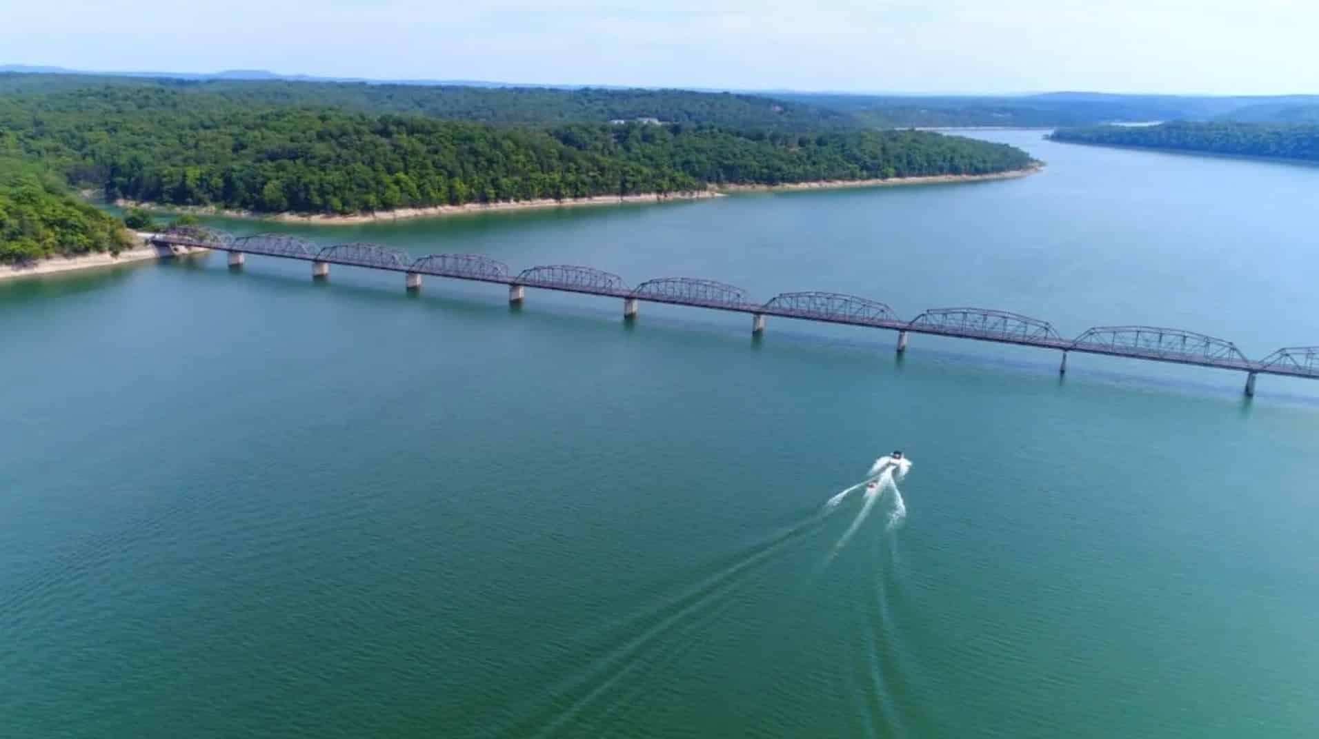
In the aerial photo below we are facing south from near the bridge at Theodosia. The tracts are about 4 miles to the east from this spot (a little farther if you are going by boat, as the lake winds around a bit).
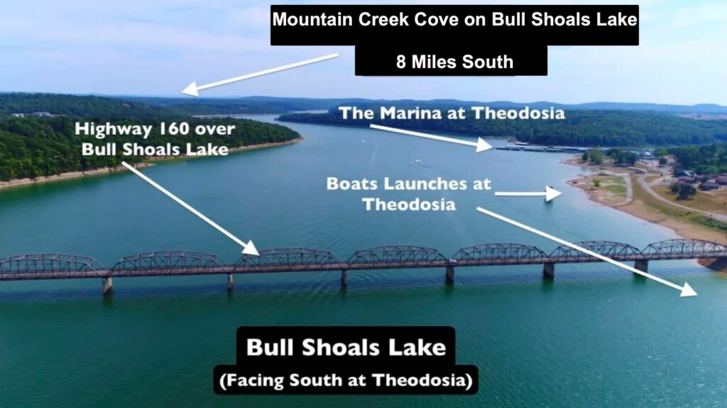
The photo below was actually taken at about the same location as the previous photo, except this time we are facing north. The town of Theodosia and a great public boat launch are on the left (but can’t be seen in the photo).

In the aerial photo above we are looking at a couple of boats on Bull Shoals Lake. The boat at the lower left side of the photo is pulling a tube with several riders, which is a common sight on this “family friendly” section of the lake. The photo above was actually taken at about the same location as the photo before it (the one that showed the bridge over the lake), except that in the photo above we are facing north and in the previous photo we were facing south, toward the bridge.
These tracts will sell fast. So you may want to act fast to ensure that you grab your own Mountain Creek Cove property before they are all gone!
Available Tracts
Below you will find a map showing the 4 tracts at “Mountain Creek Cove on Bull Shoals Lake” which is located in Marion County, Arkansas. Directly below the map you will see a list showing the available tracts along with their prices and some of their features. Click on the tract number of any available tract (within the list) to see the full information page for that tract. Any tracts that are marked “Not Yet Available” should be available within the next couple of weeks.
Aerial Map
Within the individual listing page for each tract we have included multiple maps, pictures and videos that show these amazing properties in more detail. When you click on an available tract in the list above you can watch the videos and see the photos and maps for that specific tract.
To see an available tract at “Mountain Creek Cove on Bull Shoals Lake” please click on one of the links in the table under the map.